Quality Mountain Days 1 and 2: Lake District
Update: I created selfie videos to document each day as I went along. I then used a Sony app to create short highlight videos. You can view them here: Day 1 (Friday) / Day 2 (Saturday)
This evening I’ve spent some time planning my first two ‘Quality Mountain Days’. As I explained in The psychology of going up a mountain, walking on Friday and Saturday in the Lake District will count as 10% of the days I need to have under my belt before starting my Mountain Leader award.
I’m aiming to fulfil all of the Quality Mountain Day criteria:
- the individual takes part in the planning and leadership
- navigation skills are required away from marked paths
- experience must be in terrain and weather comparable to that found in UK and Irish hills
- knowledge is increased and skills practised
- attention is paid to safety
- five hours or more journey time
- adverse conditions may be encountered
This post is to document my planning. I’ll update afterwards with photos I take and any notes/voice recordings I make!
Day 1: Friday 22 April 2016

Weather forecast from the Mountain Weather Service for Friday:
- Wind? Northeasterly 15 to 20mph
- Effect of wind on you? Small
- How wet? Risk snow & hail showers later. Substantially or completely dry, but later afternoon and evening, risk showers, of soft hail, or above 600m snow.
- Cloud? Very little
- Sunshine and Air Clarity? Bursts of bright sunshine, mainly morning. The air very clear.
- How cold? (at 750m): 1 to 3C, highest west Lakes in afternoon.
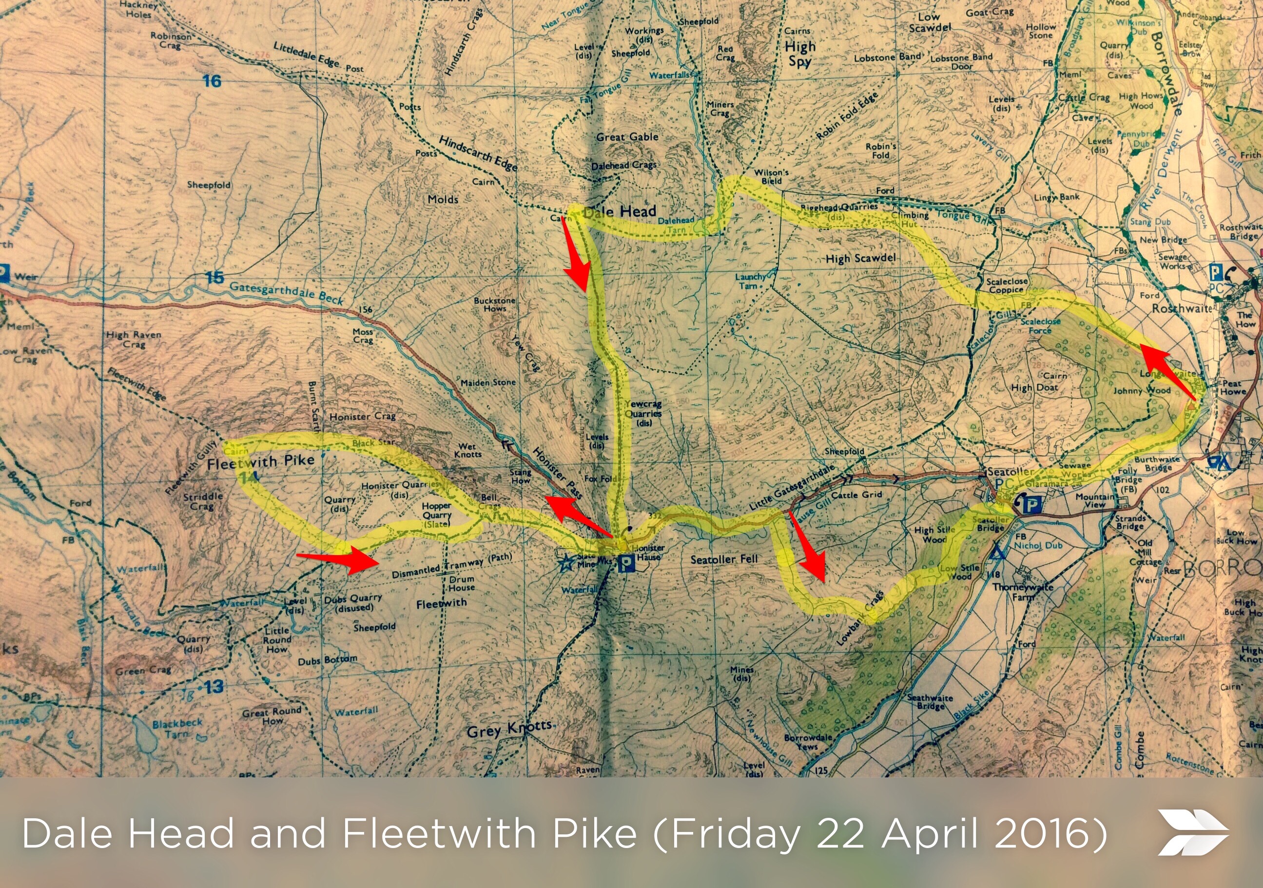
I get back home to where I live in Morpeth, Northumberland late on Thursday night, so I’ll be up early Friday morning to pack and then drive the 2.5 hours to the Lake District. I’m going to give the above route plan (created using a photo of an OS map and Skitch) to the YHA Borrowdale staff with the time I left and the time I expect to be back.
While I’ve walked up to Dale Head before (last year when I did the Mountain Skills course) this will be the first time I’ve been up there by myself. In fact it’s the first time I’ll have been up any mountain alone. I’m planning to push on, past Yewcrag Quarries and over onto Fleetwith Pike. It may be quite exposed and windy over there, so my backup plan is to abort that small circle part of the route and head down the dismantled tramway.
Either way, returning via Honister House should be pretty straightforward and the route should be reasonably flat once I’ve got down to Lowbank Crags. If I’ve worked this out correctly it should be about 14km. That should be quite enough to keep me going for the five hours I need to be out and about for it to count as a ‘Quality Mountain Day’!
Day 2: Saturday 23 April 2016

Weather forecast from the Mountain Weather Service for Saturday:
- Wind? Northerly 20 to 25mph, strongest Pennines
- Effect of wind on you? May impede walking some higher areas. Notable wind chill for late April.
- How wet? Snow and hail showers. Light showers or flurries developing, snow or soft hail to low levels, spreading increasingly from north by afternoon.
- Cloud? Mostly very little
- Sunshine and Air Clarity? Occasional bright sunshine. Visibility superb, but much reduced during showers and where also in cloud.
- How cold? (at 750m): 0 or -1C
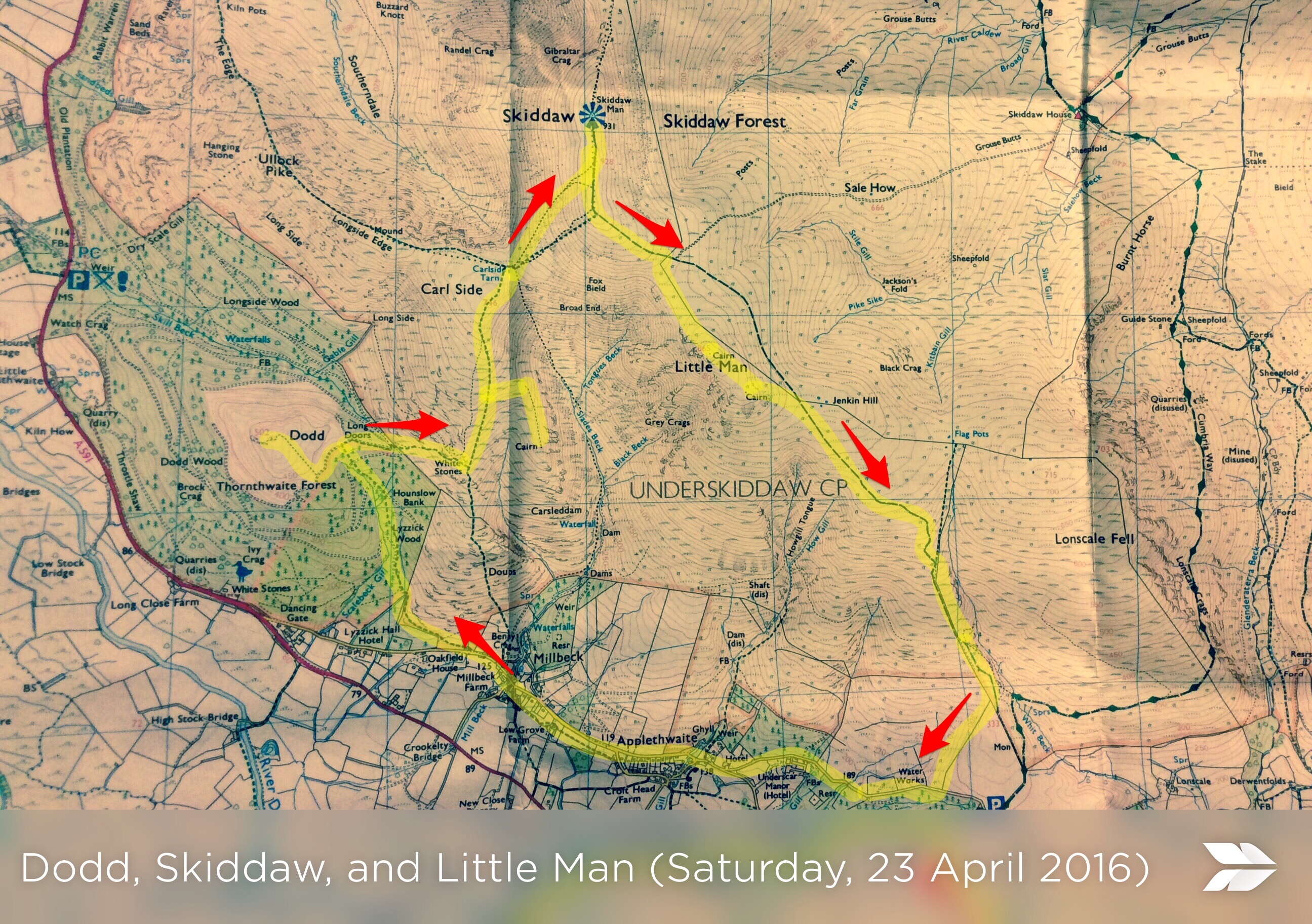
I want to get out, get up, and get home as soon as possible on Saturday — especially given the snow flurries forecast for the afternoon. I’m planning to park in Millbeck, then walk through Lyzzick Wood and up Dodd. This should give me some indication as to whether it’s safe to head up towards Skiddaw via Carl Side.
If it is, I’ll go that way, stopping off to test my micro-navigational skills by finding the cairn indicated on the map. Instead of taking the main path to the top of Skiddaw, I’m going to take the smaller track and see if I can keep on it. I’m hoping that visibility will be good enough to take some decent photos from Skiddaw Man.
After something to eat, if I can see the weather coming in, I may retrace myself and come down the track that follows Slades Beck. However, the plan is to keep going and make my way to Little Man, finding the two cairns shown on the map. From there I’ll follow the path down and round to Applethwaite, then back to the car. All told, that’s around 11km, but will be more challenging than Friday due to the weather.
Note: many thanks to Craig Taylor for responding so quickly and comprehensively to my Twitter DMs. I wanted to check that these routes seemed reasonable and he gave me some ‘old-timers’ advice that should ensure I have a safe and successful trip. Having done the Mountain Leader qualification himself (and been in the army) he’s been a great source of encouragement and support, loaning me some books last year to help with my understanding of what’s required!


Let me know when its time to get some Cairngorm Days under your belt Doug – always happy to take people up the hill in my back yard. Great to see you thriving as always! OB
That would be great, Ollie! I’ll be in touch 🙂